Project
Highway 41 Corridor Improvements
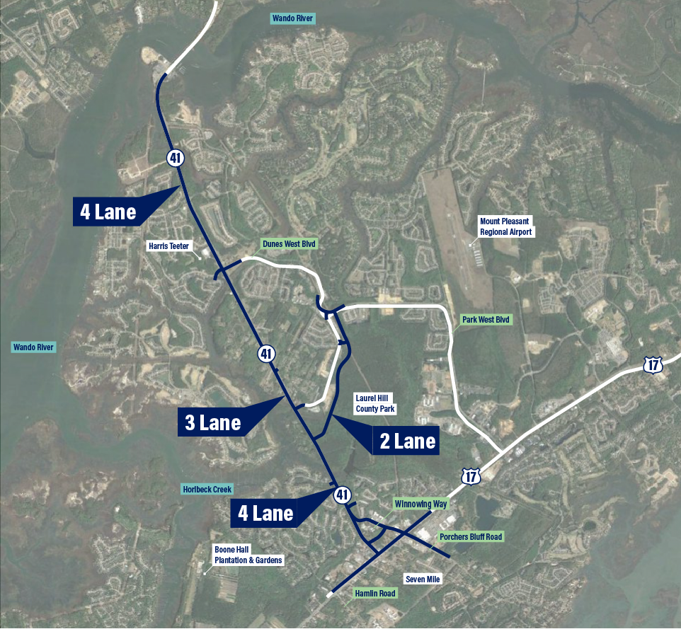
Highway 41 in Charleston County is currently a two-lane road extending between the intersection of US 17 in Mount Pleasant to the Wando River bridge.
A recent Compromise Alternative for Highway 41 seeks to limit impacts to both nature and community. Charleston County and its design and engineering consultants have submitted plans to the Army Corps of Engineers and the S.C. Department of Health & Environmental Control to review and issue the necessary permits to move this compromise forward.
You can help advance this balanced approach to improving Highway 41 by submitting comments in support of the project before July 10. You can submit comments by emailing Jeremy Kinney at [email protected]. The project can be identified by the file number: SAC-2018-00205.
Short on time? Use our template to send a message to the U.S. Army Corps of Engineers letting them know you support the Compromise Alternative for Highway 41.
_______________________
In 2020, Charleston County proposed widening Highway 41 to five-lanes through the Phillips community, a historic African American settlement area founded in 1875. The Phillips community, along with the Conservation League, many advocacy groups, and hundreds of residents from across Charleston County stood up and spoke out against the original proposal that would have destroyed Phillips, whose residents have been working hard for years to preserve their community while living with the scar of Highway 41 that was cut through their neighborhood in the 1940s.
Charleston County listened and responded by shelving that initial plan and redesigning a Compromise Alternative that balances the needs of all the communities along this portion of Highway 41 while minimizing impacts to the natural environment. In 2021, Charleston County Council voted unanimously to move this plan forward.
The vision of the Conservation League has always been one of nature and community in balance. This Compromise Alternative for Highway 41 is in absolute alignment with our values. Yes, wetlands will be impacted, but any substantial improvements to Highway 41, including the alternative proposed in 2020, would have impacts to wetlands. With this Compromise Alternative, impacts to both wetlands and communities are minimized as much as possible and dispersed equitably throughout the project area. No single community has to bear the brunt of the impacts. And of course, any impacts to wetlands will require mitigation in accordance with state and federal policy.
The Issue
Highway 41 was built in the early 1940s when a small dirt road that meandered between former plantations and around the Phillips community, a historic African American settlement area, was realigned and widened to its present configuration. That new highway cut straight through the middle of Phillips, which had no say in the matter at the time.
In the late 1980s and early 1990s, the Town of Mount Pleasant began annexing large tracts of former pine plantations owned by Georgia Pacific for large suburban developments. The first, Dunes West was originally designed to have a four-lane parkway run through the development with access points on Highway 41 and US 17, with 41 being a limited-use back entrance. The original developers sold out while the development was under way to multiple developers who divided up the land into Dunes West and Park West and the proposed parkway was only built as a two-lane road. The Town also approved several other large developments along Highway 41, which caused the traffic to get progressively worse.
In 2005, the Phillips community worked with the Conservation League to develop a plan that would widen Highway 41 to three lanes with roundabouts at Joe Rouse Road and Dunes West Boulevard. The additional lane would provide a safer option for cars needing to turn in and out of their driveways for those living along Highway 41. It also would have left 16’ buffers along both sides of the road for trees to be planted and multiuse paths to be installed along Highway 41. This plan was adopted by CHATS as a viable solution to a four-lane road that had been proposed, but funding for the project was never identified and the lane was never added.
In 2016, Highway 41 was included in the project list for the County’s half-cent sales tax program. That same year, the County’s planning department completed a multi-year long cultural resource survey that identified numerous Reconstruction Era African American communities throughout Charleston County as historically significant. Phillips was one of those communities and the South Carolina Department of Archives and History determined Phillips to be eligible for inclusion on the National Register of Historic Places as a potential historic district associated with post-Civil War African American History.
After the sales tax passed, an alternatives analysis began in early 2018. The County and their consultant, HDR established a community stakeholders committee to help review a dozen different alternatives for Highway 41. The Conservation League and representatives from Phillips, along with at least a dozen other interest groups and government agencies sat on that committee. The county kept advancing Alternative 1, widening the present Highway 41 in place to five lanes, while also developing other alternatives that would redirect Highway 41 around Phillips.
Throughout this process, Phillips and the Conservation League kept pushing for the community’s original three-lane proposal through Phillips while pushing for any five-lane corridor that the County desired to construct to go around the community.
In 2019, all of the alternatives were eliminated except for Alternative 1 and a new alternative was developed – 7a, which would three lane the exiting 41 through Phillips and a new five-lane road would go around Phillips generally following the Bessemer Road/Dunes West Boulevard. Alternative 7a got broad support from the Phillips community but was widely opposed by the Dunes/Park West communities.
In August 2020, the county announced to Phillips that they had decided to eliminate 7a and move forward with Alternative 1 as their preferred alternative. The county argues that the increased wetland impacts associated with 7a and the $30 million additional costs and slightly slower travel times were the reason to eliminate Alternative 1.
Since 2020, the Coastal Conservation League and the Phillips community have developed a broad coalition of organizational and citizen advocates to work together to oppose Alternative 1 and the destruction that it would have on the historic settlement community. Environmental, historic preservation, legal, mobility, and community development organizations along with thousands of residents have submitted letters to Charleston County officials, written op-eds and letters to the editor and circulated petitions opposing Alternative 1. The Conservation League has shared a petition opposing Highway 41 that has received over 1,600 signatures in support of protecting the historic Phillips community.
As a result of the broad support for protecting the historic Phillips community, Charleston County has not move forward with its recommendations to move Alternative 1 through the NEPA process. County Council is expected to receive an update about the project in early 2021.