Attend the Public Input Meeting on March 7 to learn about Mount Pleasant Way from the Town of Mount Pleasant staff and others. You will have the opportunity to ask questions and provide input about this proposed project and other infrastructure issues.
Residents may have questions about road and pathway safety, potential community amenities, impacts on their homes and settlement communities, and the methods of property acquisition proposed by the Town. Town officials will be on hand to address these and other infrastructure questions.
You can also provide input on the public survey, available online until March 15.
For more project information, community members can reach out to James Aton, the project manager, at [email protected] or (843) 856- 3080
Public Input Meeting
Rifle Range Road Trail of Mount Pleasant Way
Thursday, March 7, 2024 at 5:30pm
Mount Pleasant Waterworks
1619 Rifle Range Road, Mount Pleasant, SC 29464
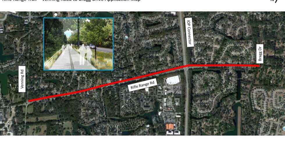
WHAT IS THE RIFLE RANGE TRAIL?
- The segment of Rifle Range Trail proposes a 10-12 foot multi-use path along the west side of Rifle Range Road replacing the existing 5 foot sidewalk, from Venning Road to Bragg Drive.
- The purpose of this segment is to promote better and safer connectivity from residential and commercial areas for people walking and bicycling.
- The design phase is estimated to be about an 18-month process and construction would be approximately 12 months.
WHAT IS MOUNT PLEASANT WAY?
- The Mount Pleasant Way project is a proposed network of connected multi-use paths intended for people walking and bicycling that will link key portions of the Town, including recreation facilities, parks, schools, neighborhoods, commercial zones, etc. It will also result in a connected system of trails and greenways.
- The Mount Pleasant Way project was finalized in the Town’s 2019 Comprehensive Master Plan and Long-Range Transportation Plan. The Master Plan was completed and adopted in 2021.
- It proposes approximately 47 miles of shared-use paths that are a minimum of eight feet in width with a preferred width of ten feet.
- Originally envisioned as a system of linear parks, Mount Pleasant Way includes opportunities for new park space of varying scales, including pocket parks, cultural neighborhood gateways, and more.